Project to Help Forecast, Detect and Monitor Different Environmental Hazards in GCC Region’s Coastal Waters
 Abu Dhabi-UAE: 11 August, 2013 – Masdar Institute of Science and Technology, an independent, research-driven graduate-level university focused on advanced energy and sustainable technologies, today announced the launch of a collaboration project with Bayanat for Mapping and Surveying Services, a Mubadala Company, to develop water quality monitoring tools in the Arabian Gulf using the satellite receiving station at the research-based institution.
The Ocean Color (OC) Research Group at the Earth Observation and Hydro-Climatology (EO-HC) Lab at Masdar Institute is leading this project with Bayanat, a specialist in the UAE’s geospatial sector. The OC Group, led by Dr. Hosni Ghedira and Dr. Taha Ouarda, presently includes a team of two post-doctoral researchers, an IT engineer, a Geographic Information Systems (GIS) developer, one field and lab engineer and three research assistants.
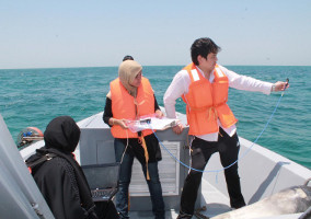
Mariam Rashed Al Shehhi and Muna Rashed Al Kaabi – UAE national doctorate students well-trained in satellite data collection and processing techniques –– are collecting measurements from the sea in order to conduct their experiment that relates to water quality assessment and monitoring. They are also involved in the lab analysis of these samples.
The OC Group is currently undertaking several research projects focusing on the development of new satellite-based tools to forecast, detect and monitor different environmental hazards in the UAE’s coastal areas and the Arabian Gulf region. The project also covers water turbidity mapping, red-tide detection monitoring and forecasting, oil spills detection and monitoring, in-house atmospheric correction algorithm adapted to the regional climate, impact assessment of the discharge of desalination plants on the coastal ecosystem of the UAE, as well as ocean circulation model for the Arabian Gulf.
Khaled AlMelhi, CEO of Bayanat for Mapping & Surveying Services, said: “Our collaboration aims to tap Masdar Institute’s expertise in developing new satellite-based tools to detect environmental hazards. We have provided the research team with a vessel to conduct sea cruises and deploy the instruments for measurements during the research project. We hope the synergy between the two organizations will bring benefits of the region.”
Dr Fred Moavenzadeh, President, Masdar Institute, said: “Our collaboration with Bayanat reflects the relevancy of our research efforts that aim to bring extraordinary value the region. With the guidance of the country’s leadership, we have established partnerships with government organizations to help the UAE and the GCC region tackle environmental hazards ahead of time. We believe this joint project will provide more productive tools that can be deployed by all the countries across the globe.”
Bayanat aims to provide both a strategic capability for the UAE and support both the government and commercial sectors with high quality national level geospatial products and services. Its team of geospatial services professionals specializes in ‘Data Acquisition, Processing and Analysis’, ‘Geospatial Data Visualization and Cartography’, and ‘GIS applications’ Development and Geospatial Consultancy’.
Dr Hosni Ghedira said: “This project is the first of its kind in the Gulf region and will provide information on marine resources management and sustainable development of the coastal and offshore zones. The tools we are developing can help Abu Dhabi reduce economic losses at fish farms by providing advanced warning of an upcoming ‘red tide’ so they can move their stocks and sensitive species. It will also save money for the government’s desalination plants by facilitating early closure before an algal bloom, thus preventing contamination damage to the plants. Advanced warning of bloom will also ensure that the water utilities will have time to make alternative solutions for customers before a desalination plant is closed.”
The EO-HC Lab has its own satellite receiving station getting real-time SEVIRI images from the European Satellite Meteosat (one image each 15 minutes) and MODIS (operated by NASA). This data is used by the OC team to derive real-time Sea Surface Temperature (SST) and other dust-related products for the water turbidity project. SEVIRI data is also used to improve atmospheric correction model implemented in the OC products.
The satellite station is also receiving higher resolution data from NASA’s MODIS satellite (twice daily). This data is also used to produce daily assessment of oil spills, Chlorophyll concentration, red-tide coverage and water turbidity. Historical scenes from the high-resolution Landsat satellite (30-m) are also used to improve oil spills product. Currently, the OC team is developing red tide forecasting tool by coupling daily chlorophyll maps with ocean circulation data derived from the Hybrid Coordinate Ocean Model (HYCOM).
Serving as a key pillar of innovation and human capital, Masdar Institute remains fundamental to Masdar’s core objectives of developing Abu Dhabi’s knowledge economy and finding solutions to humanity’s toughest challenges such as climate change.
Established as an on-going collaboration with the Massachusetts Institute of Technology (MIT), Masdar Institute integrates theory and practice to incubate a culture of innovation and entrepreneurship, working to develop the critical thinkers and leaders of tomorrow. With its world-class faculty and top-tier students, the Institute is committed to finding solutions to the challenges of clean energy and climate change through education and research.