A new technique from Khalifa University combines satellite imagery with machine learning to automate and improve the detection and mapping of archaeological features in the UAE and other desert regions.
In the sandy stretches of the United Arab Emirates, modern technology is revealing secrets of the past. At Saruq Al-Hadid, an archaeological site tucked into the Rub’ Al-Khali desert in Dubai, researchers are pioneering new methods in satellite remote sensing to uncover hidden artifacts and potential archaeological sites. The sophisticated techniques used could revolutionize how we discover and study remnants of bygone eras.
The use of imaging radar in archaeological research is not new, but its application has gained traction in recent years. Unlike traditional methods of ground surveys, which can be time-consuming and arduous, especially in challenging terrains such as deserts, remote sensing offers a wider and more detailed perspective. The technology allows researchers to survey vast areas from above, spotting signs of past human activity, avoiding all terrestrial obstacles to their identification.
Satellite imaging and radar have been successfully used in various archaeological studies globally, focusing on everything from geological investigations to vegetation mapping. In arid, sandy and dusty regions like the UAE, the application of this technology faces unique challenges. Here, the interference of dust particles and cloud cover can degrade the image quality and dune formations and patterns can interfere with identifying remnants of human activity. Advances in radar sensors and their signal penetration abilities can overcome the dust challenge, but the unique landscape still poses a problem.
A team of researchers from Khalifa University’s Earth Sciences Department has harnessed the power of artificial intelligence and machine learning to take remote sensing a step further. They combined satellite images with machine learning for advanced image processing and geospatial analysis to understand the Saruq Al-Hadid site better, helping to automate the processes and test its feasibility.
Dr. Diana Francis, Head of KU’s Environmental and Geophysical Sciences (ENGEOS) Lab, Charfeddine Cherif, Research Associate, and Dr. Steve Griffiths, Professor of Practice and SVP Research and Development, collaborated with Prof. Kosmas Pavlopoulos and Dr. Haifa Ben-Romdhane, Sorbonne University Abu Dhabi, and Dr. Hosni Ghedira, Mohamed bin Zayed University of Artificial Intelligence. Their results were published in Geosciences.
“The driving force behind this research was to enable the UAE to discover archaeological sites and features hidden under the sand,” Dr. Francis said. “Given the climate and the fact that much of the country is desert, it was too difficult logistically to inspect the desert from the ground. That’s why satellite data was key. Then, we needed to have technology that can see beneath the sand.”
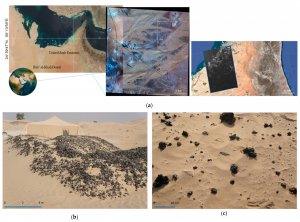
Figure 1. (a) Left inset: Saruq Al-Hadid archaeological site (24°39′47″ N 55°13′55″ E). Middle inset: Worldview-3 multispectral image (left scene—19 August 2019; central scene—19 November 2019; right scene—9 January 2019). Right inset: ALOS-2/PALSAR2 (L-band) image (2015-05-17T20:15:36Z). (b) Metalworking slag interspersed with metal artefacts, ceramics, and other cultural material. (c) Slag artefacts on the dune surface extending to over 1 km2 post-excavation.
This pioneering study is the first to apply such advanced techniques to the area, expanding upon previous work that combined radar remote sensing technologies with traditional archaeological practices. The goal of this project goes beyond mere discovery, aiming to develop a benchmark for national and regional remote sensing capabilities, which can be generalized to larger areas.
The researchers hypothesize that the artifacts found so far at the site were produced on-site, indicating potential hidden settlements nearby. Using machine learning algorithms, they developed an automated process to extract features from Synthetic Aperture Radar (SAR) data and perform geospatial analyses. The results have been promising, with detected areas on the site correlating with those already under excavation and revealing potential new archaeological zones.
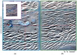
Figure 2. Worldview-3 colour-balanced RGB orthomosaic of the Saruq Al-Hadid site located in the mobile dune fields of the northeastern edge of the Rub’ Al-Khali desert, captured on 26 November 2019. (a) Western zone of observation. (b) Eastern zone of observation.
Of course, the process isn’t without its challenges. The desert environment, dominated by sand and sparse vegetation, presents a limited range of spectral signatures which can be problematic for machine learning algorithms. The varying surface interactions, such as those with sand dunes and rocky outcrops, add further complexity. However, researchers expect that the modeling and prediction accuracies will improve as they incorporate more data from recent field surveys and integrate a neural network and backpropagation algorithms.
“The dunes are fascinating on aerial and satellite imagery; they look like ocean waves, but sand,” Dr. Francis said. “For me, the fascinating thing was when the machine learning model indicated to us the potential area for excavation — and it turned out this was the one archaeologists had already started to explore. It validated the method.”
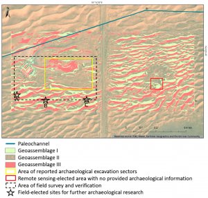
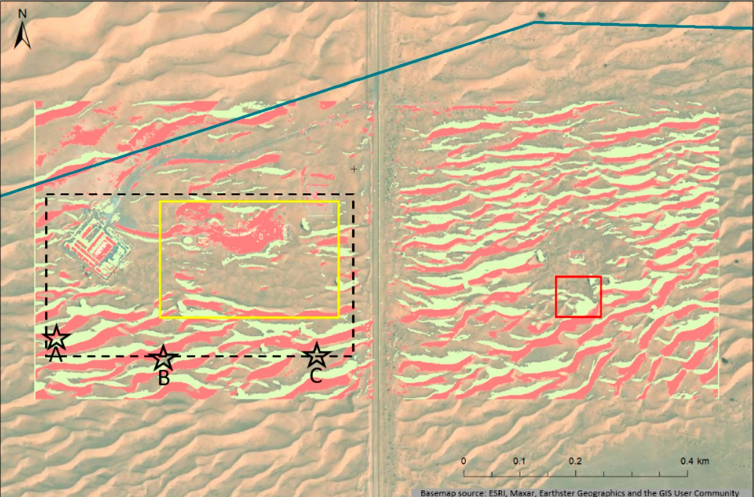
Figure 3. Reclassification of the study site, based on its landscape context and multimodal data, into three main geomorphological assemblages. The area of field survey and verification contained the reported main excavation sectors and surroundings. Based on the field surveys, three site locations were elected for future archaeological investigation
This research not only has implications for the future of archaeological studies but also for our understanding of paleo-drainage systems within the study area. It’s anticipated that the process’s applicability and efficiency will improve with more recent field surveys and further validation efforts using multi-temporal data. The techniques developed here could be adapted to better serve archaeological research in larger areas and similar environments, thereby illuminating the past and guiding future studies.
Moreover, this research suggests the potential for long-term, comprehensive investigations into the prehistoric landscape of the study site and similar environments. A workflow integrating machine learning and deep learning techniques with automated feature detection could generate and validate detections of unidentified archaeological objects and sites. This would enhance archaeological training datasets and aid in the identification of significant areas, predicting potential site locations, and formulating more informed research strategies for future investigations.
“This research represents a proof-of-concept on how SAR imagery and machine learning can guide archaeological searches in a desert environment,” Dr. Francis said. “The methods we developed work for all arid regions and it’s my hope we can apply it to the whole of the UAE and then take it to other desert areas in the region. These areas are still unexplored but we know they have cultural history.”
These findings represent a significant leap forward in the integration of cutting-edge technology and archaeology, showing that even in the harshest of environments, we can unearth the stories of our past. Who knows what other secrets lie waiting to be discovered beneath the sands?
Jade Sterling
Science Writer
06 July 2023